Our ambitious transatlantic project, a collaboration between the MPIWG Department I group “Knowledge in and of the Anthropocene,” Berlin’s Haus der Kulturen der Welt, and a host of academic, artistic, and community partners in the United States, recognizes this need. Over the course of one year a combination of field-based research projects, public forums, educational events, and online materials interrogates the entire Mississippi River watershed as a critical zone of long-term human-environment interaction and recently accelerating transformations.

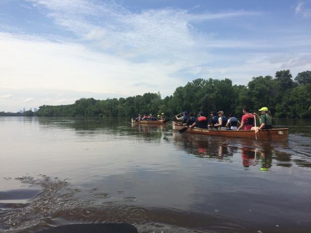
Project members canoeing the Mississippi River near Minneapolis. Photo: Christoph Rosol.
The Mississippi River Basin comprises almost 40 percent of the landmass of North America. Today, the river acts as a corridor for industry, agriculture, and trade. Its path and flow are a product of twentieth-century hydraulic engineering. In a territory burdened with racial legacies and social conflict, this hydrosocial system is increasingly threatened by catastrophic failure as a result of twenty-first-century climate change and associated weather extremes. Biodiversity loss, land degradation, sediment-starved loads, and petrochemical contaminations place increasing pressure on ecosystems and impose systems of social and environmental injustice. The Mississippi is a model for grasping the Anthropocene both in situ and globally, a specific geographical system and window into the world’s future. It exemplifies local topography as much as it extends toward a global topology of Anthropocene dynamics.
A Transdisciplinary Framework for Researching the Mississippi
In our one-year project, five “Anthropocene River Field Stations” cover regions along the river, bringing local and international teams of scientists, artists, activists, and experts together to investigate site-specific material and historical conditions. Meanwhile, an “Anthropocene River School” links this distributed research to collaborative teaching exercises both online and onsite. In fall 2019 a group of students and researchers will take an “Anthropocene River Journey” largely by canoe, connecting research sites from the Headwaters down to the Gulf of Mexico, and carrying insights downstream. Finally, a one-week “Anthropocene River Campus,” held in New Orleans, will mark the climax of the project, informed and leveraged by the research work of the Field Stations. Throughout this whole period, the project and its findings will be presented and discussed on a tailor-made online platform.
Field Station St. Louis
In March 2019, around 60 project members traveled to St. Louis, Missouri to investigate one of the Field Stations in America’s Heartland. Part of a constellation of “rust belt” cities stretching across the Midwest, deindustrialization has cast the city as one of North America’s most economically depressed and dangerous places. Across the river, the flood plain of the American Bottom reveals layers of historical sediment, a “site of the social and spatial systems of pre-contact Native Americans, nineteenth-century industrial expansion, twentieth-century infrastructural consolidation, and twenty-first-century ecological precarity,” in the words of landscape architects and artists Jesse Vogler and Matthew Fluharty.
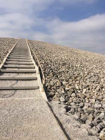
The visit to St. Louis consisted of workshops, field trips, and public events including a Field Campus organized by Kim Fortun and Scott Knowles. Local documentarian Tony West took a group of participants to Weldon Spring Remediation Site, an unintentional monument to the Anthropocene. During World War II the nearby Mallinckrodt plant, established by three German brothers in 1867, proved a decisive part of the nation-wide Manhattan Project, allowing uranium to be refined at an industrial scale. Its legacy is a 23-meter-high tomb of 1.13 million cubic meters of irradiated soil, rising from Mississippi-carved lowland, entombed for millennia.

Weldon Spring disposal cell.
Photo: Thomas Turnbull.

Shell products display, Wood River Refinery Museum. Photo: Thomas Turnbull.
Outside of St. Louis, east of the river confluence with the Missouri, the small settlement of Wood River became home to a Royal Dutch Shell refinery in 1917. Today, it is a vast facility connected to a continental network of pipelines drawing in hydrocarbons, primarily Albertan bitumen and crude from the Gulf of Mexico. Each day this is processed into 165,000 barrels of gasoline and 90,000 barrels of aviation fuel, shipped via the Mississippi to customers across the country and burned worldwide. Such sites demonstrate how the postwar “Great Acceleration” in the mobilization of energy, matter, and biota has superimposed a new topology upon Earth’s surface, transforming localities into nodes within a planetary extractive network.
Further south stand the remains of Cahokia Mounds, one of the richest archeological sites in North America. A public symposium provided an opportunity to recognize that humankind’s impact on land-use and ecology long precedes Western colonization. Researchers from the Max Planck Institute for the Science of Human History in Jena and archeologists from Washington University in St. Louis discussed pre-contact species migration, seed dispersal, and domestication processes in the wider Mississippi region.


Photographs showing the erasure of "The Big Mound" in what is today the center of St. Louis. Source: Missouri History Museum, St. Louis. Easterly Daguerrotype Collection, 1852.
A subsequent transect walk took the group out into the fields, passing by polluted super-fund sites and similarly monumental earthworks composed of landfill, on the way to Granite City. There, east of St. Louis, where the local steel mill has recently been reopened due to the Trump administration’s tariffs, a community initiative has transformed empty streets and houses into a laboratory for local artists and designers working at the intersection of art and landscape.

Transect Walk through the American Bottom near St. Louis. Photo: Christoph Rosol.

Local steel mill in Granite City. Photo: Christoph Rosol.
The Transcalar Nature of the Anthropocene
Visits to “thick” Anthropocene localities such as St. Louis and its surroundings reveal that much of what we understand as global is deeply nested within local settings. Triangulating between different domains of knowledge production, field-oriented practices, and civic engagement helps make sense of the fractal nature of the Anthropocene and the scale-transcending relations it involves. The Mississippi River project therefore provides a new and more adequate mode of understanding place and situatedness in times of great upheaval.
